
GPS tagging
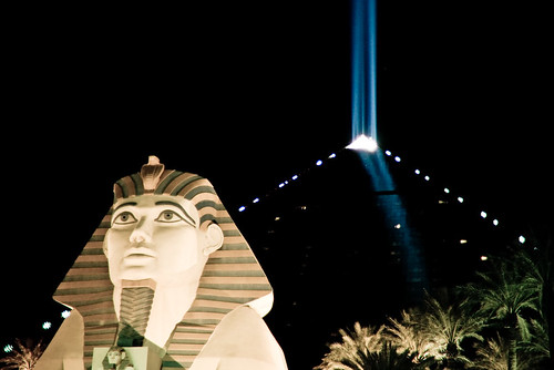
50mm, 1/40sec @f1.4, ISO 1600
I have looked in to some options of combining GPS data with the photos I take. For a few hours I thought about writing my own software, I also found the open source Happy Camel project and considered using that. Eventually I realised that the download software that I already use, Downloader Pro, has a GPS option in the latest version. I tried it out briefly prior to traveling to Death Valley but didn't really spend much time working out how to use it. Turned out that it was exceptionally easy to use. I'm really impressed. There's a 30 day evaluation available if you were interested in trying it out.
The GPS isn't connected to the camera at all. There's no wires or wireless connection. I don't have anything new mounted on the camera hot shoe, unlike some other GPS tagging solutions. All I have to do is switch on the GPS unit and put it in my bag. It is creating a tracklog of where I go and when. The time on the GPS and the time on the camera need to be synchronised, or you at least need to be aware how different the time is (you can enter the difference in the downloader software). Once you've got that worked out, the GPS knows where you are at a given time and the camera knows when you take a picture (it is recorded in the photo's EXIF data). That's all you need to know to pretty accurately tag where the picture was taken. All that is left is to combine the two and fill out the GPS data field in the photo's EXIF data. That's where Downloader Pro comes in.
I have a Garmin GPSmap 60CSx GPS unit. It has a 10,000 point automatic track log, so when I switch it on, it starts tracking. I'm sure this sort of track log can be generated by any GPS unit that can connect to a computer. (GPSBabel might be useful to convert to a format that Downloader Pro can understand). When I get back to my computer, I plug the camera's compact flash card into a card reader and hook up the GPS unit via USB. I switch the Garmin into the USB mass storage mode so that it appears as a hard drive on the computer. In that mode the latest track logs are available in the root of the drive. Downloader Pro is configured to scan removable drives for track logs. (Under GPS Settings, enable Geo-Tagging, set the camera and GPS clock times and for Track Log Settings select 'Search removable drives').
Once Downloader Pro is configured, I simply plug in the GPS, plug in the CF card, set a job reference name and hit download. Everything else happens automatically. I don't have to convert track formats, it already understands the Garmin GPX log format. Simple. You can also produce Google Earth and Google Maps viewable versions of the track log. Next thing I want to try is integrating the images into Google earth to have the shots hanging in space. For now though, when I load up the images in Lightroom there is a new field filled out in the EXIF - the GPS co-ordinates where the image was taken. The 'location' set of metadata browsing in Lightroom shows all this in a concise form. You can then click on the arrow to the right of the GPS data and a web page is opened to Google maps, showing the satellite view of where the image was taken.
I also found out that in Flickr, you can change your account permissions, so that it will automatically extract the location information when you upload images. This then places them on the map and indicates where the image was taken automatically. The option is off by default and is under You->Your Account->Privacy & Permissions in the Import EXIF location data option. You can set different permissions on each image for who can see the location data and who can see the image. So you could let anyone see the pictures but only friends and family know exactly where it was taken, for example.
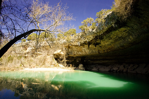 If you click on the shot of Hamilton pool, above, you can use the show on map option in the lower right to see where it was taken.
I am interested in any good examples of using geo-tagging in photos. It seems like a neat technology and fun to be able to see exactly where you were when you took a shot. I did use it quite a bit while scouting locations too, to mark a spot that I wanted to return to at a better time of day. Really then all I could have done was hit the mark button on the GPS and put a suitable name in. So far I've found this useful for sharing the location with others, more than anything else. When talking through the images, I could click on the GPS link and pull up the satellite view - handy to show just how far away from anything I was. In some other shots, it has been useful to be able to describe the route and thought process taken to finding a particular location. I have considered using it when out shooting in an urban area, to tag locations with great backgrounds for portraits - there are plenty around Austin and I occasionally forget where they are. Again there the information would be more useful for sharing those spots with others that might want to visit. I can already see my shots appearing automagically in Google Earth, when I switch on the flickr layers, which is quite neat. I'd actually like to work out if it is possible to include my images as floating billboards in Google Earth, when you fly past the location where they were shot. That might require directional information though, to really line up the scene.
Useful Links
If you click on the shot of Hamilton pool, above, you can use the show on map option in the lower right to see where it was taken.
I am interested in any good examples of using geo-tagging in photos. It seems like a neat technology and fun to be able to see exactly where you were when you took a shot. I did use it quite a bit while scouting locations too, to mark a spot that I wanted to return to at a better time of day. Really then all I could have done was hit the mark button on the GPS and put a suitable name in. So far I've found this useful for sharing the location with others, more than anything else. When talking through the images, I could click on the GPS link and pull up the satellite view - handy to show just how far away from anything I was. In some other shots, it has been useful to be able to describe the route and thought process taken to finding a particular location. I have considered using it when out shooting in an urban area, to tag locations with great backgrounds for portraits - there are plenty around Austin and I occasionally forget where they are. Again there the information would be more useful for sharing those spots with others that might want to visit. I can already see my shots appearing automagically in Google Earth, when I switch on the flickr layers, which is quite neat. I'd actually like to work out if it is possible to include my images as floating billboards in Google Earth, when you fly past the location where they were shot. That might require directional information though, to really line up the scene.
Useful Links
- Geotagging on Wikipedia
- Geotagging on Flickr
- Geocoding photos on Wikipedia
- Imageingester pro (another tagging program that I hear works well on the Mac)


8 comments:
Gordon,
Does it set EXIF data on JPEG files only, or does it tag the RAW file as well??
Hi Andreas, it actually creates a sidecar xmp file with the GPS data in it, alongside the original RAW file.
When you process the RAW file, that data gets merged into the EXIF data on the final JPEG.
The flickr geotagging group is a pretty good resource if you haven't checked that out already.
I was hoping to get the PhotoGPS for my Dad for Christmas - seemed more likely that he'd use an all-in-one type solution than muck around with matching up data with additional software - but apparently they are never actually going to release it.
Hi Mk, that PhotoGPS looks like you still have to use some sort of integration software post shot (least the description mentions that), the only differences I can see to using it with a normal GPS is:
1/ it knows exactly when you took the shot (I assume it'll get tripped by the normal flash trigger) so it is fractionally more accurate if you were say running :)
2/ takes up the hotshoe so you can't use a flash or a bubble level
3/ can't help you much if you get lost
Gordon,
On my Mac (sorry windows folk), I've lately been using an application called "GPSPhotoLinker") - it can even do such shameless things as interpolate position based on the track log (i.e. if you shot a photo inbetween two track measurements), and a few other things. Looks like it just sticks the info into the EXIF data (no XMP sidecar), and I suspect it would work with both raw and jpg.
Brilliant minds think alike, my friend. I just bought a Garmin eTrex Venture HC last week and I've been looking into the same thing. I stopped short of your research however, because I can't really think a way in which I'm going to benefit from geotagging. I don't travel much, I don't use flickr, etc.
But it is very cool technology.
Hi Milo, thanks for commenting.
I have similar thoughts - I'm not entirely sure what I'm going to use it for, if anything. I do know that for quite a lot of the pictures I take, people ask where the locations are. This makes it a whole lot easier to answer.
Something else I've contemplated doing a few times is making a bit of a catalog of great portrait backgrounds around the Austin area, this would be a great way to do that, too. I wouldn't need to bother with tracking or putting them on a map, just carry the GPS when I shot them.
Ahh XMP! Nifty. Thanks.
Post a Comment